A summer at the top of the world: My journey to the Northwest Passage
- C GE

- Apr 17, 2020
- 15 min read
Cynthia Garcia-Eidell, Ph.D. candidate, Earth and Environmental Sciences, University of Illinois at Chicago - Participant on the Northwest Passage Project research cruise (Jul. 16 – Aug. 6, 2019).
Introduction:
The Northwest Passage Project (NPP), launched back in 2016 and supported by the National Science Foundation (NSF), aims to increase awareness and understanding of a changing Arctic. The project strives to conduct a research expedition taking place in summer (around the peak of Arctic sea ice minima) onboard Arctic seafaring vessels. This year, we are extremely lucky to be onboard the mighty RVIB ODEN of the Swedish Polar Secretariat as we cruise and break ice (or crawl on top of ice) within and around the channels of the Canadian Arctic Archipelago (CAA).

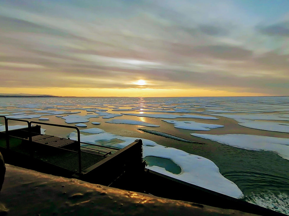
Helicopter shot of our temporary home for the coming weeks (taken 20/07/2019 inside Pond Inlet).
The NPP expedition provides scientists and students with the opportunity to deploy all kinds of oceanographic instruments (CTDs, ROVs, UAVs, ship-based sensors, etc.) within this harsh and remote area to help understand how the waters of the CAA have changed as a consequence of the secular warming trend over the Arctic Circle. This year, the research has evolved and expanded to include elements of the natural system, such as physical oceanography, biogeochemistry of Arctic waters and atmosphere, at-sea distribution of marine birds and mammals, and microbial population sampling and identification. I hope that through these entries, you (and I for that matter) can learn something about working in the Arctic, and potentially use the data to be obtained on this cruise to increase our understanding of this critical, yet poorly understood region of our global climate system.
DAILY BLOG ENTRIES:
17 July 2019 (Wednesday)
I am writing from the RVIB Oden – a Swedish research vessel managed by the Swedish Polar Secretariat currently carrying a fleet of scientists, students, and a film crew on a voyage to the Arctic, specifically along the Northwest Passage including northern portions of Baffin Bay and waterways within the Canadian Arctic Archipelago (CAA).

You are probably asking, why the Northwest Passage and the CAA? We have a number of questions that we will attempt to answer in this cruise. One of them deals with understanding how the waters flow in the region. A significant feature of the CAA are the major flow pathways that act as conduits for the Arctic ocean freshwaters to the warm, salt(ier) waters of North Atlantic. Sources of freshwater in this region can come from melt from sea ice, land ice, and meteoric water sources. Freshwater coming from the north (mostly coming from melt from areas that are permanently covered by sea ice), and from the northwest (potentially from freshwater released by the Beaufort Gyre, which are mostly from river run-off). Past observations suggest that the Beaufort Gyre – a clockwise, wind-driven, ocean circulation, released some of its freshwater, following years of ‘spin-up’ and freshwater accumulation. On the other side of this region, some scientists have also observed the intrusion of warm North Atlantic waters. In a way, the dynamics of the flow and mixing in the CAA is complicated because you have a number of major sources and opposing forces. Whether we will observe the same freshwater release, or the hypothesized ‘atlantification’ of the CAA, we are not sure. Either way, with the use of a suite of equipment, we hope to understand the mixing patterns in this region, and whether we are experiencing a new regime of freshwater release from the Arctic.
While changing sea ice, and larger atmospheric patterns and circulation are responsible for the dramatic changes in the region, we are also interested to investigate the regional freshwater budget. In other words, where is the water coming from? And how much are they contributing to the CAA freshwater fluxes? Through my research at the University of Illinois at Chicago, and through the collaborations with other science teams in this expedition, I am hoping to provide insights into the relative contributions of sea ice and meteoric exports in this region through the use of complementary salinity, nutrients, and O-18 measurements.
You are probably asking again, why should I care about the freshwater dynamics and budget in the Arctic and the CAA? Well, many scientists have hypothesized that a huge influx of freshwater into the wider global ocean could slow down or significantly suppress the global ocean circulation. This could potentially trigger temporary cooling effect, drastic precipitation changes, local rise in sea level, among others. This is a great example of our saying that “what happens in the Arctic, doesn’t stay in the Arctic”. In addition to this, quantifying the freshwater budget in this poorly studied region serve as a benchmark in understanding whether the hydrologic cycle is accelerating, and how the ocean dynamics is evolving in the face of climate change.
I will try to share more into the activities being carried out on-board in the following days (especially our work on continuously measuring greenhouse gases throughout the cruise). But for now, we are powering through setting up all of our equipment so we can start collecting data. Stoked to get started!
18 July 2018 (Thursday)
Now that all the equipment are set, and that we had most of our safety toolbox talks, tours, and trainings done, I am feeling more or less at ease. We are still trying to go through the motions of the activities and understanding all the experiments/data collection protocols of each groups. Together with the expedition science head, Brice, and my group members, Alessandra, Frannie, Theresa, Humair, Nick, and Samira, our group (we fondly call “the Chemistry Department”) are in-charge of collecting water column and atmospheric chemistry related to the fluxes and sources of greenhouse gases. We are also interested in looking at how microorganisms metabolize methane and if it is enough to offset the methane that escapes the atmosphere. This, along with the water stable isotopes and other ocean parameter measurements that we are collecting (briefly discussed in my earlier blog post) are our primary responsibilities.
How do we collect our data and samples? For the seawater sampling, discrete profiles of carbon isotopes of CO2 and CH4 are measured from water collected form the CTD rosette. Methane oxidation rate experiments will also be conducted using gas-tight foil bags, spiked with isotopically-labeled methane gas (thus acting as incubation bags). These bags will be sampled every 12-24 hours to determine rate of change of methane inside the bags. In short, we are trying to see how fast the bugs are eating the methane. As for the atmospheric component of this experiment, Frannie and I were able to set up a laser absorption spectrometer to analyze the concentration and stable isotopic composition of CO2 and CH4 in the atmosphere. This was made possible in cooperation with our collaborators from Stockholm University that already has pre-existing air inlets and tubing that runs to the container lab. We teed-off from their 20-m air inlet that feeds into their LGR eddy covariance system (also measuring CO2 and CH4 concentrations). After initial checks and calibrations, we are now continuously measuring and logging data in real-time! Unlike our other experiments, this set-up is pretty much hands-off after the initial set-up, which is pretty sweet. All that is needed are our daily checks and weekly calibrations. Another component of our group is the collection of water samples for particulate organic carbon and nitrogen, dissolved organic carbon, and cDOM. Through this, along with the ship underway measurements, we will attempt to characterize the effects of freshwater, whether from meltwater or from meteoric sources on the base of the food web, carbon cycling, and ocean acidification state.


As for the water stable isotopes and complementary salinity measurements, we are collecting water samples from the CTD rosette as well as from the surface of the ocean through good ol’ bucket sampling. Bucket sampling is done by throwing a weighted bucket offboard to sample the surface of the ocean every 6 hours (5am, 11am, 5pm, and 11pm). Aside from sampling for water isotopes analysis, we are also recording the sea surface salinity (SSS) and sea surface temperature (SST) at each spatial and temporal point. Why collect the very top surface of the ocean? Well, as introduced on my first entry, the water isotope-salinity relationship (let’s call this δ18O-S relationship from hereon) can differentiate water masses. Different hydrologic processes, whether it is sea ice formation and melting, run-off, evaporation, and precipitation, produce unique slopes along the relationship between δ18O-S. Since this region (and the whole pan-Arctic for that matter!) is so sparsely sampled for water isotopes, this is a great opportunity to contribute to the understanding of the freshwater budget in complement with the other ocean parameters we are measuring. Surface measurements are also crucial in taking advantage of readily available satellite measurements in the last decade. Just in 2009, we have started measuring SSS from space through the launch of the Soil Moisture and Ocean Salinity (SMOS) satellite by the European Space Agency (ESA), and the Aquarius and Soil Moisture Active Passive (SMAP) satellites by the National Aeronautics and Space Agency (NASA). Through our ODEN-borne measurements along with a historical matched-up surface δ18O and SSS from space, we will attempt to model δ18O distribution in the pan-Arctic. Our hope is that in the end, a high-resolution, gridded δ18O data set in the Arctic and CAA can potentially be used for hydrologic models as an additional constraint on surface water fluxes in polar oceans. Paleoceanographic studies can also use δ18O data sets to calibrate coral and foraminiferal data sets. Aaand lastly, the SSS and SST measurements obtained in this region can help to further validate and calibrate our satellite-derived data sets too.
I might have bored (or entertained?!) you with all of our group’s activities onboard, but this are just pieces of the whole puzzle that the NPP expedition is trying to solve. We might be here for just this year’s summer melt season, but hopefully, our (somewhat painstaking) data collection and observations can provide some useful insights into the changes in the carbon cycle, nutrient, and hydrologic cycle in an ever-changing Arctic.
Off to the CTD training… Will write more tomorrow.
19 July 2019 (Friday)


After the flurry of initial activities, a more regular routine is starting to emerge. Yesterday, our group, a.k.a. the Chemistry Department got initiated with the basics of casting a CTD. I am especially excited to learn this process because I have been using data from CTDs, but have zero idea on how they were obtained! A CTD or Conductivity, Temperature, and Depth is a rosette of niskin bottles that samples ocean waters at varying depths. A suite of sensors is attached on to the rosette to measure temperature, salinity, dissolved O2, and fluorescence on both the up cast and downcast. For the rosette water sampling, we followed the CLIVAR/GO-SHIP sampling protocol with a “water cop” keeping track of the sampling order. Sampling for methane goes first, followed by nutrients, water stable isotopes, and finally for microbiological and DNA sampling.
As we go through one cast after the other, it was awesome to see the faces of our teammates light up as we get into the rhythm of a CTD operation. So much efficiency and team work! It almost felt like we were born to sample Arctic water! Of course, this would not be possible without Brice’s (our Science head and team leader’s), incredible sea of knowledge, and saintly patience. All in all, a great day of training and water sampling.
20 July 2019 (Saturday)
Everything is starting to sink in. We are actually doing fieldwork in the Arctic! We are also doing this not just on any vessel, but onboard the mighty RVIB Oden. For this post, I thought I should introduce the monster of a vessel that is transporting us all in and around the CAA.

The RVIB Oden, is a combined escort icebreaker and research vessel, operated by the Swedish Polar Research Secretariat (SPRS). According to a brochure I found in the Oden bridge, the Oden is the first non-nuclear icebreaker in the North Pole in 1991. With a total power of 24,500 hp, it is built to smash through almost 2 meters of ice at 3 knots or crawl on it if the ice is particularly thicker. Between the years 2006-2011, the Oden conducted five successful cruises to Antarctica, and has been upgraded and fitted with advanced scientific equipment. It also features heeling pumps that allow the ship to heel from one side to another with a maximum angle of 7° in 15 seconds, and two water pumps that can be used to reduce the friction between the hull and ice during ice breaking, and as thrusters in open water conditions. Aside from the sheer power of the Oden, our fieldwork activities are also made possible by the amazing members of the SPRS (shot-out to Lars and Asa!), two helicopters (Ted and Adam as our pilots), and a number of zodiacs.

The Oden is getting old, and will probably go on for several more years (according to Lars, about 16 years to go). However, with the seemingly growing geopolitical and economic race to the Arctic, newer, bigger, and more powerful icebreakers are expected to also arrive in the scene. Some even coming from nations that are not members of the Arctic Five nor the members of the Arctic Council. Most notable of these are the icebreakers coming from east Asian nations such as China, Japan, and Korea. When talking with Matts, one of the officers onboard the Oden, he shared their concern about the growing competition in the region. The Oden is perhaps ‘old’ now, but it is probably one of the best carriers and witnesses of how the polar regions have changed in the last three decades.
As I walk the halls of this powerful icebreaker, I can’t help but wonder about all of the science that has transpired here and all of the discoveries that it made possible. I feel blessed and excited of the thought that I am walking the footsteps of the other polar scientists before me and that I am also now a part of the Oden’s Arctic-going history.
21 July 2019 (Sunday)

We just had a warm, sunny, summer day in Pond Inlet today and was able to visit a Nunavut community of 1,600 people. Ina, served as our tour guide showing us the major buildings in their small town, including a gas-powered plant, sewage treatment facility, major town halls and Nunavut government buildings, the library/museum, a Coop store (basically a giant grocery store), a coffee shop, and the one and only hotel in town (which can cost you about $500/night).
Through this experience, we get to interact with the locals and the adorably curious kids of the community. I was taken aback that the Nunavut kids are first, weirdly curious about the type of phone you own, and second, whether you have a boyfriend/girlfriend. These were not the questions I expected nor wanted to start a conversation with them. However, I just went with the flow and was surprised (again) when they showed me their shiny iPhones, and when they shared that they already have gfs/bfs! After these conversations, along with our short trip to their Coop store that is filled with western goods and normal items found in your typical neighborhood grocery stores, I set aside my initial idea of an Arctic indigenous community that relies on subsistence living and are oblivious about modern technologies. Clearly, the community and the new generations here are adopting and adapting to the changes in their environment and the world.

With a taste of the same comforts that people like us from lower latitudes have, I wonder, why do they still decide to stay here? Aside from the harsh environments and challenging access, their resources are also very limited (which in turn drives the prices of local commodities waaay up). I asked this question to Ina and she responded, ‘…because this is home. This is where family is’. She continued that despite the hardships, families within the community try to help each other. For example, when one family catches a narwhal or a caribou, it is guaranteed that they will share a portion of the catch with the other families in need. This is with the hopes that they will get something in return when other families catch something as well. Families helping families and communities supporting each other. This makes me smile thinking that there is still a place like this in the world where people genuinely care about each other.

While I sit on top of a really really old rock, overlooking and admiring the breath-taking view of Pond Inlet, I breathe in the sweet Arctic summer air. Beautiful wild flowers blanket the landscape and I start to think that if this is also my ‘home’, perhaps I would also have a hard time leaving.
24 July 2019 (Wednesday)

After a couple of days of equipment calibration, CTD casts, and water sampling, we are today taking a break to visit an island, discovered to be the burial site of four (now known) members of the rescue mission for the ill-fated Franklin expedition. After an exhilarating helicopter ride with Ted, we landed on to a barren, and arid Beechy island. There are no signs of life. Touching the loose rocks beneath my feet and scouting this almost alien environment, the only thing that you may find captivating are the big chunks of sea ice strewn along the beach (which we collected samples from later on). These beautiful, white and pale blue ice are slowly melting through the action of waves, and the 24-hours of summer sunlight. Sara and Hester then proceeded with their spiel on the history of the Franklin expedition and then lead our group to a short hike towards the four marked graves. These were the four young seamen who got trapped in the island after their ship got over wintered in an attempt to find Franklin. The marker reads:
“Sir John Franklin of the Royal Navy and his crew of 129 men entered the waters of Lancaster Sound in search of the Northwest Passage in July 1845. Although they were never again seen by Europeans, Franklin’s party was the largest and best equipped sent by the British Admiralty to the Arctic Archipelago in quest of a navigable northern route to the Far East. The Admiralty’s search for the missing expedition began two years later and continued until 1880. The expedition’s progress has been traced from its first over-wintering harbor on Beechey Island to Starvation Cove on the mainland where the last survivors perished. After exploring Wellington Channel to 77° N, the crew passed the first winter at this camp. The following summer, Franklin probably sailed along Peel Sound and the strait which now bears his name. His ships, HMS Erebus and HMS Terror were beset by ice to the north of King William Island in September 1846, and remained so until April 1848 when they were abandoned. Franklin died on 11 June 1847. Led by Francis Crozier, Captain of the HMS Terror, the remaining 105 crew members traveled south along King William island, towards the mainland. Many died of starvation on the route. A small band of about 30 men crossed to the mainland and finally perished at Starvation Cove. A tent camp, navigational cairns and posts, and these graves mark the expedition’s stay on Beechey Island.”

Looking at the Northwest-facing tombstones, I am curious about ALL the lives the quest for a Northwest Passage has taken. It is indeed a coveted route that is envisioned to save both time and money for major economic players. Together with the Northern Sea Route along the coasts of Russia, and the still hypothetical Transpolar Route, the role of the northern high latitude as a shipping hub in an ice-free Arctic is extremely likely.
27 July 2019 (Saturday)
Today was a glorious day! We went on the first ‘ice station’, which is a day set aside to get us scientists and students out on the sea ice. To do this, we helicoptered off the Oden to find a nice, thick looking ice floe. Once a reasonably solid sea ice is found, we slowly but surely lowered down, with the helicopter pilot testing the ice floe by landing and slightly taking off a couple of times. The excitement builds on when Ted the pilot gave Brice a thumbs up and motions him to get off to test the ice. Brice went ahead and checked the surroundings and the ice around the chopper and motioned back to Ted with two thumbs up. We are officially on our ice station!


After all the safety checks and putting on the floatation vest and ice spike necklace, the only thing left for us to genuinely worry about was a polar bear attack. Thankfully, Ted has a pretty serious looking shotgun to protect us from any stealth attacks. We worked next to an ice ridge too, which apparently are the best hiding spots for polar bears. After checking all the safety boxes, we then proceeded in preparing our ice coring area. Ice cores aid the investigation into the internal properties of sea ice, which include methane, water isotopes, nutrients, DOC, and cDOM, as well as for microplastics. We drilled the first core and measured the temperatures of 10 cm section. I collected 20 cm sections of water stable isotopes, while Brice collected 5 cm sections for methane. Whole ice cores where drilled for nutrients, and microplastics. Thankfully, no ice corer nor essential hardware were lost in the operation.
Once the cores were drilled and completed, our job for the day was over and we treated ourselves with a sip of (surprisingly refreshing) melt pond water. We packed our things and said good bye to our ice floe. A couple more pictures on the ice and we decided to retire back to the Oden.


All in all, it was a really fun day of sea ice science. I am really growing quite fond of this Arctic fieldwork!
To cap an amazing day, we had our regular fancy Saturday night dinner at the Oden, and the UIC contingents decided to wear Hawaiian shirts. Here are some pics of us ironically wearing tropical shirts in the Arctic. So much love and sea ice fun.


General reflections:
As cliché as this may sound, this cruise has given me a real understanding of both the beauty and also the complexity of the Arctic. As someone that has now attempted to understand the Arctic using satellite sensors, witnessing the scale of change in sea ice, ocean circulation, and atmospheric and water chemistry (albeit for only a few weeks) through this cruise is truly an eye-opening experience. The melt ponds, one-year ice formation, melting and break-away of multi-year ice, release of GHG from the Arctic to the atmosphere, magnitude of freshwater release, and response of the biological components – not one of these variables are well understood. We clearly have a long way to go before we can fully grasp how these parameters would behave, both in a seasonal sense and in response to continued global warming. But hey, as a graduate student just having a taste of Arctic fieldwork, this sounds like an amazing challenge to me.
###


Comments